‘First-of-its-kind’ mobile 3D mapping system will scan 2 million data points a second
The University of Bradford (UK) has taken delivery of the UK’s first Leica TRK700 Evo - a vehicle-mounted mobile mapping system capable of capturing two million data points every second to a resolution of 1mm.
The state-of-the-art device will be used to expand Virtual Bradford, the digital twin of the city, which initially covered 1.5 square miles of the historic city centre and has been expanded to cover Saltaire.
Professor Andrew Wilson, from the School of Archaeological and Forensic Sciences, said: “We’re delighted that the University of Bradford now has the very first Pegasus TRK700 Evo unit in the UK. This has been made possible by substantive investment from the Arts & Humanities Research Council’s (AHRC) Capability for Collections (CapCo) fund and has already been put to work documenting Saltaire World Heritage Site, as part of ‘People, Heritage & Place’, one of nine knowledge exchange projects funded through the AHRC Place Programme.”
Tom Sparrow, Senior Scientist in Visualising Heritage who has been at the forefront of working with data captured with the Leica TRK described the potential of this: “The first run with the new device captured the Canal Road link between the City Centre and Saltaire, as well as the entirety of Saltaire World Heritage Site in just two and a half hours – a distance of 29.18 km with 87,471 images and a total of 2,050,834,333 exported points.”
Professor Chris Gaffney, Pro-Vice Chancellor for Research & Innovation explained: “We enjoy a close working partnership with City of Bradford Metropolitan District Council and are delighted to see the importance of digital twins in place-based research at a time when Bradford is developing the runway to 2025 and Bradford’s role as UK City of Culture.
“As we continue to work together to extend the reach of Virtual Bradford, it is clear that the use of transformative digital technologies to develop digital twins will help the city, its residents and visitors in a multitude of different ways.”
The TRK is one of several new mobile mapping devices bought by the university through the AHRC CapCo scheme which paves a roadmap towards enhanced national capability for conservation and heritage science, amongst other applications. Further capabilities include a ‘BLK2FLY’ autonomous flying laser scanner and a ‘RTC360’ terrestrial laser scanner. They will use ‘SLAM’ (Simultaneous Localization and Mapping) technology, a method used for autonomous vehicles that enables users to build a map and localise vehicles in that map at the same time.
Steven Duffy, reality capture specialist at Leica Geosystems said: “As part of the investment made by the University of Bradford, there’s the Leica TRK700 Evo, the BLK2FLY autonomous flying laser scanner, and the BLKARC autonomous laser scanning module for robots, as well as the RTC360 terrestrial laser scanner, and a multitude of software to enable the University of Bradford to be able to scan and progress towards their targets in capturing Bradford and beyond.”
Shane Gwilt, mobile mapping and utility detection manager for Leica Geo Systems in the UK, said: “The TRK700 Evo system [has] a combination of sensors including two Z+F profilers, picking up a million points of data per second each, along with the camera attachments giving us high resolution colourised point cloud data, with SLAM technology and a range of other sensors to provide accurate real-time positioning data whilst on the move. This is a fantastic acquisition for the university… and it’s a fantastic partnership.”
Virtual Bradford is fundamental to Bradford Council’s approach to data-driven decision-making and as an open dataset will be used to boost investment in the city with applications ranging from regeneration by developers through to the Bradford 2025 Delivery team who are already considering using Virtual Bradford as a method of signposting events and places.
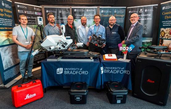
Picture at top of page: Virtual Bradford represents a collaborative partnership between the University of Bradford and City of Bradford Metropolitan District Council. Right to Left - Prof Chris Gaffney (Pro-Vice Chancellor for Research) and David Shepherd (Strategic Director for Place, City of Bradford Metropolitan District Council), with Professor Andrew Wilson (University of Bradford), Adrian Walker, Syd Simpson, Joe Ritchings (City of Bradford Metropolitan District Council) and researcher Joe Moore (University of Bradford), shown with a range of 3D capture assets including Leica TRK700 EVO mobile mapping system, BLK2FLY and RTC360 terrestrial laser scanner.
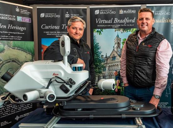
Second picture: Steven Duffy (L), Reality Capture Specialist at Leica Geo Systems, and Shane Gwilt (R), mobile mapping and utility detection manager for Leica Geo Systems with the Leica TRK700 EVO mobile mapping system at the University of Bradford.
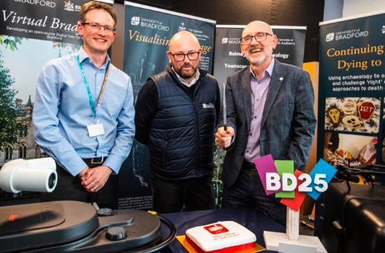
Third picture: (L to R): Prof Andrew Wilson, David Shepherd (Strategic Director for Place, City of Bradford Metropolitan District Council), Professor Chris Gaffney.