Europe's Lost Frontiers
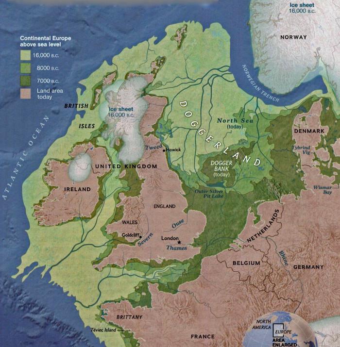
The only lands on Earth that have not been explored in any depth by science are those that have been lost to the oceans. Global warming at the end of the last Ice Age led to the inundation of vast landscapes that had once been home to thousands of people. These lost lands hold a unique and largely unexplored record of settlement and colonisation linked to climate change over millennia. Amongst the most significant is Doggerland. Occupying much of the North Sea basin between continental Europe and Britain it would have been a heartland of human occupation and central to the process of re-settlement and colonisation of north Western Europe during the Mesolithic and the Neolithic.
Within this submerged landscape lies fragmentary yet valuable evidence for the lifestyles of its inhabitants including the changes resulting from both the encroaching sea and the introduction of Neolithic technologies. This inundated landscape cannot be explored conventionally, however pioneering work by members of this project has led to the rediscovery of Doggerland through the creation of the first detailed topographic maps relating to human occupation in the Early Holocene.
Within the Europe’s Lost Frontiers project, world-leading innovators in the fields of archaeo-geophysics, molecular biology and computer simulation are developing a ground-breaking new paradigm for the study of past environments, ecological change and the transition between hunter gathering societies and farming in north west Europe that will involve the following elements:
Ground-breaking research
There are three main components to the proposed research which significantly advance the state of the art within archaeology and specifically aim to:
- Release the full potential of the vast seismic reflectance data sets available (generated mainly by the petroleum and wind industries) to create topographical maps of early Holocene Doggerland that are as accurate and near complete as possible. This will develop and extend methodologies pioneered by the project team.
- Use ancient DNA recovered directly from buried sediments under the sea floor (rather than from fossils contained in these sediments) as a vital new tool for the reconstruction of the palaeoenvironments of Doggerland. Sedimentary ancient DNA will be used to explore the development of these landscapes during the period of climatic amelioration and specifically to look for markers associated with Neolithic practise within the marine environment that may not be recognised via traditional methodologies. The study is enabled by next generation sequencing that delivers DNA sequences much faster and cheaper than has hitherto been possible, combined with the cool stable environment of marine sediments in which biomolecular preservation is exceptional over the Holocene timescale and beyond.
- Model the ecological development of Doggerland using complex systems modelling approaches that simulate real ecological processes grounded in the behaviour of individual organisms. Although these approaches present methodological challenges on the scale proposed, their successful application will allow more realistic and dynamic modelling than is possible with conventional approaches.
While each of these three components involves substantial innovation, either in techniques or in their application, combined together they provide the opportunity to unlock the scientific study of major inundated landscapes. Although the focus of the research will be on Doggerland, the techniques and overall approach are transferable to other drowned landscapes, such as Beringia, the lost land between Alaska and Siberia, or Sundaland, which linked continental Malaysia with Indonesia and Borneo. As with Doggerland, the key role that these sunken landscapes have played in human prehistory and the peopling of the globe is recognised, but appropriate techniques for their detailed scientific study have remained elusive.
The proposed research is timely, not simply in terms of the availability of the data and technology to realise this ambitious project. Just as the possibility of mapping Doggerland and modelling its dynamic ecological and human history has become a reality, this uniquely well-preserved but fragile prehistoric landscape has come under unprecedented pressure from trawling, mineral extraction and infrastructural development, including most recently the construction of extensive wind farms. The European nations around the North Sea have begun to put in place the frameworks for the management of this shared heritage, but the ability to succeed is critically dependent upon having a better understanding of the resource that we wish to both protect and exploit. This project will fundamentally advance that understanding.
Seismic mapping
Until recently, maps of Doggerland were based on little more than informed guesswork. The breakthrough came when members of this project were able to show that extensive seismic reflection surveys carried out for other purposes, notably petroleum exploration, could be used to map the topography of ancient drowned and buried landscapes. This led to the initiation of the North Sea Palaeolandscapes Project, which has now mapped some 45,000km2 of inundated prehistoric landscape, an area somewhat larger than the Netherlands. The mapping has been achieved mainly using 3D seismic data donated by PGS (Petroleum Geo-Services) from their Southern North Sea Mega Merge. The Mega Merge combines more than 60 different surveys, carried out at different times and by various groups, migrated into a single data set. Analysis of the top slices of this huge 3D seismic data set has involved much methodological innovation and resulted in maps showing the rivers, lakes and hills, coastlines and estuaries, wetlands and salt marshes of a large part of Doggerland, sometimes in extraordinary detail. It must be stressed that the seismic reflection data used in this project, provided at no cost for research purposes, required the expenditure of several hundred million Euros to collect. The use of this data for a purpose that was not intended – the mapping of Holocene landscapes – is highly innovative, currently unique and constitutes extremely cost-effective research.
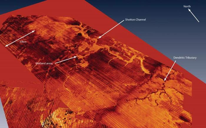
The completion of mapping the Southern North Sea Mega Merge represents a revolutionary achievement for landscape archaeology which has been recognised at an international level through the award of the 2013 European Archaeological Heritage Prize, and brings the ultimate goal of the near total mapping of the lost Mesolithic/Neolithic landscapes of Doggerland within reach. One aim of the present proposal is to extend the mapping of Doggerland to achieve the maximum coverage possible. This cannot be achieved just by doing ‘more of the same’. Whilst new data sources, including surveys associated with the recent wind farm development, have become available, the coverage of 3D seismic data remains incomplete. Much of the North Sea is covered only by 2D seismic data, and the intensity of this coverage is variable. As the name suggests, 2D surveys comprise single lines of seismic reflection data (a single streamer is towed behind the survey vessel) producing single vertical profiles through the seabed geology. By contrast 3D survey comprise multiple lines of seismic reflection data collected simultaneously (multiple streamers are towed behind the survey vessel), a method that readily facilitates horizontal mapping.
Over recent years, the team has devoted considerable research effort to exploring the possibilities of using the extensively available 2D data both to map areas not covered by 3D data and to enhance the interpretation of 3D data (in general the 2D data has better vertical resolution). This work has shown that, with the development of appropriate methods, the 2D data can be used to produce adequate mapping – it has achieved proof of concept. Building on this research, the present project will attempt to achieve the maximum possible mapping coverage of Doggerland using all available seismic data, including new 2D data from wind energy generation which has a proven ability to locate landscape archaeological features, but which has not yet been used for the purposes of wide scale landscape generation. A successful outcome would be a major research achievement, and an international ‘first’ opening up several new horizons.
Environmental analysis
A programme of targeted coring will focus on two major river valleys of Doggerland that have been mapped using 3D seismic reflection data. Each ‘core’ will be described and then assessed for the presence/absence and state of preservation of organic material suitable for ‘conventional’ palaeoenvironmental analysis (pollen, plant macrofossils, insect remains, ostracods/foraminifera and diatoms) and radiocarbon determination. Radiocarbon and OSL samples will be submitted initially for ‘rangefinder’ dates. Cores assessed to have sufficient potential will then be analysed in further detail. Samples taken from each core for conventional palaeoenvironmental analysis will be paired with corresponding samples taken for sedimentary ancient DNA (sedaDNA) analysis, facilitating direct comparison of results. Comparison of the results of the sedaDNA analysis and of analysis of conventional palaeoenvironmental proxies will underpin this research, and will allow the issue of potential leaching of DNA through sedimentary strata to be addressed (see below). For the purposes of sedaDNA analysis cores will be maintained for long-term storage at –20°C.
The conventional environmental programme of the project is designed to produce a new, detailed and temporally controlled set of data contributing to the reconstruction of the past climate and landscape of a large area of the North Sea plain. This will be available for direct comparison to the results of the sedaDNA work. Potentially, this aspect of the project will impact on a number of present climatic and landscape models for the late Glacial and the Early Holocene in Northern Europe, including the relative density of grazing herds and the degree of openness in woodland and other landscapes. The environmental data also has the potential to give direct insights into past human action in the landscape throughout the period of time represented; particularly how Mesolithic people may have manipulated the landscape through forest burning, landscape clearance and alteration.
Sedimentary ancient DNA
In 2010 ancient DNA (aDNA) was hailed in Science magazine as one of the top ten ‘big ideas’ of the previous decade. However, aDNA has most commonly been obtained from anatomically intact material, such as hair, bones and teeth. It has only recently become clear that aDNA can also be retrieved from other materials, including sediments – a discovery which has the potential to revolutionise the study of paleoenvironments. This macrofossil-free DNA (commonly referred to as sedimentary aDNA or sedaDNA) can provide information about the flora and fauna of the past and has the potential to allow in-depth reconstructions of palaeo-ecosystems.
Preliminary research indicates that most plant and animal sedaDNA is of local origin, with insignificant dispersal of DNA over long distances, and that cross-strata leaching is not an insuperable problem, particularly if quantitative methods are used. The pilot study by this project team has established that the stable cool environment of marine sediments is highly conducive to the preservation of ancient DNA over tens of thousands of years. While previous studies of deeper time ancient DNA have been restricted to high cool latitudes, this fundamental advance hails a release on latitudinal constraints of previous ancient DNA studies because of the global nature of the preservation environment.
The sedaDNA analysis will be carried out in pursuit of two broad aims:
- General environmental reconstruction scan. This will use current bar coding community profiling approaches to scan for palaeoflora and palaeofauna over the entire core set.
- Targeted Metagenomic transects through dated horizons. The first stage will help guide the in depth sampling of a series of samples in transects through cores. The metagenomic approach developed by the team is 20-30x more sensitive than the barcoding approach in the first stage. This will allow for more complete palaeoenvironmental reconstruction, and particularly the detection of organisms associated with Neolithic activity. This will test the hypothesis of Neolithic activity on the North Sea plain prior to inundation and build substantively on the results of the pilot study.
The extraction of ancient DNA from the cores will be complemented by a programme of sampling of the same cores for ‘conventional’ environmental proxies (pollen, plant macrofossils, insect remains, ostracods/forams and diatoms), together with samples for radiometric dating (up to 400 radiometric dates and 100 OSL dates are proposed). Comparison of the results of sedaDNA analysis and the results of analysis of conventional proxies will be an important component of the research, and will allow the issue of potential leaching of DNA through sedimentary strata to be addressed.
Computer simulation
The data from the seismic mapping, sedaDNA and palaeoenvironmental analysis can then be used to build dynamic models of the changing geomorphology and ecology of Doggerland, from the opening of the Holocene around 10,000BC until its eventual total inundation around 5,500BC. In an ambitious departure from conventional approaches, the intention is to use complexity systems modelling approaches such as Agent-Based Modelling (ABM), for the modelling of ecological processes and simulating the dynamic interaction between the environment and the animals and plants which inhabit it.
This cannot be achieved by conventional modelling methods, which are both static and 'top-down'. The complex processes that emerge from the interaction between species and their effect on the environment require a modelling method which can simulate change through time and is able to simulate the dynamic interactions of a changing landscape and the flora and fauna which depend on it. ABM mimics nature’s decentralised, ‘bottom up’ processes, taking individual organisms as its building blocks. It simulates individual plants and animals and the rules which govern their interactions with each other and the environment. ABM allows different hypotheses and 'what if?' scenarios to be explored through dynamic simulations, and processes such as plant and animal colonisation and the interactions between flora and fauna to be modelled in detail. With this we can simulate the effects of individual variation, spatial processes, variation in growth patterns, cumulative stress, and natural complexities with fidelity and levels of detail that is difficult or even impossible with conventional models.
While the principles of complex systems modelling are well established and the approach has been used by the group, the scale of the modelling which will be attempted for Doggerland has little precedent, and developing the appropriate methodologies and software tools will form a significant part of the work. This will take advantage of the group’s pioneering work on distributed simulation infrastructure to create a system whereby the models can be processed across networks of computers simultaneously.
Further information
University of Bradford research Lead: Professor Vincent Gaffney.
- For news, visit the online app: Europe's Lost Frontiers teamapp
- ADS archive for the North Sea Palaeolandscapes Project
- ERC project webpage
- National Geographic article on Doggerland
- Archaepress site for Mapping Doggerland with download link -
- SPLASHCOS project page
- Lost Frontiers Facebook page
- Lost Frontiers Twitter account
- Lost Frontiers article in The Independent