Old Scatness Broch and Jarlshof Environs project phases
Phase One
The first phase of the project was one of definition, identifying the extent of Iron Age settlement and excavating the later elements of settlement which overlaid it.
1995
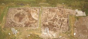
Two trenches were laid along an east-west axis, bisecting the broch and producing a cross-section of the mound. The western trench was designed to examine a rectangular near surface resistivity anomaly identified as a standing building on the First Edition OS map.
Both geophysical and map data suggested that the eastern trench would be for the most part clear of Post-Medieval structures and identified both the depth of Late Iron Age deposits and established the outer circumference of the broch. A third trench was excavated at the base of the mound, at the interface of a geophysical anomaly identified on both the magnetic and earth-resistance coverage. On excavation this anomaly was found to be a ditch, the area beyond which contained evidence for an early agricultural soil.
Publication: Dockrill, S.J., Bond, J.M. & Turner, V.E. 1995. Old Scatness Broch and Jarlshof Environs Project Interim Report No. 1 (Data Structure Report). Bradford Archaeological Sciences Research 1. Bradford: Department of Archaeological Sciences/Shetland Amenity Trust.
1996
The aim of the second season was to investigate the early levels established in 1995, to allow a better assessment of deposits pre-dating the post-medieval period. The main excavation trenches were extended to the south to form two excavation areas, which effectively provided two quadrants of the broch and overlying mound material. A strong Norse presence on the site was established by Norse deposits truncated by post-medieval activity, identified on the western excavation area and infilling a Pictish multi-cellular building in the eastern area.
Publication: Dockrill, S.J., Bond, J.M., Turner, V.E. & Purdy, A.V. 1996. Old Scatness Broch and Jarlshof Environs Project, Interim Report No. 2 (Data Structure Report) Bradford Archaeological Sciences Research 4. Bradford: Department of Archaeological Sciences/Shetland Amenity Trust.
1997
Further extension of the two main excavation areas allowed the investigation of a larger sample of the Late Iron Age settlement. This identified a complex post-broch settlement of village proportions surrounding the broch tower.
Publication: Bond, J.M. & Dockrill, S.J. (eds.). 1998. Old Scatness Broch and Jarlshof Environs Project 1997, Interim Report No. 3 (Data Structure Report). Bradford Archaeological Sciences Research 6. Bradford: Department of Archaeological Sciences/Shetland Amenity Trust.
Sponsors: British Academy, EC Objective 1 Programme, Shetland Amenity Trust, Shetland Enterprise Company, Shetland Islands Council, University of Bradford, DITT, Farquhar & Jamieson, Wackenhut UK.
Phase Two
Work within Phase Two of the excavation programme focused on the excavation of the Late Iron Age settlement and the broch. In tandem with the excavation, the survey and the heritage interpretation programmes were expanded. Site guides were introduced, providing tours of the site explaining both the archaeological sequence and how the evidence is being used to formulate interpretations of past lifestyles; previously excavation staff and students had provided tours to visitors.
A programme of building reconstructions added to the visitor experience and provided insights for the archaeologists into the construction of the buildings they were excavating. The living history group, Timezone, began to work at the site, explaining the technology and use of artefacts found on the site virtually as they were excavated.
1998
Significant expansion of the excavation area was undertaken in order to allow a much greater proportion of the Iron Age settlement to be excavated. Excavation concentrated on the definition of Iron Age features within these areas and the continued stratigraphic excavation of structures within core excavation areas.
Publication: Bond, J.M. & Dockrill, S.J. (eds.) 1999. Old Scatness Broch and Jarlshof Environs Project 1998, Interim Report No. 4 (Data Structure Report). Bradford Archaeological Sciences Research 7. Bradford: Department of Archaeological Sciences/Shetland Amenity Trust.
1999
Work concentrated on the excavation of the Iron Age sequence of buildings and the extensive sampling of midden infills and floor deposits. Some of the buildings have door lintels and first floor supports visible, indicating a significant level of survival only paralleled at Jarlshof.
An important element was the analysis of the structural remains and the floor deposits. In situ burning deposits, especially hearths, were used for archaeomagnetic dating to complement the radiocarbon dating programme. Within the broch, the latest structural phase was excavated.
Publication: Bond, J.M., Dockrill, S.J. & Turner, V.E. (eds.) 2000. Old Scatness Broch and Jarlshof Environs Project: Field Project 1999, Interim Report No. 5 (Data Structure Report). Bradford Archaeological Sciences Research 9. Bradford: Department of Archaeological Sciences/Shetland Amenity Trust.
2000
2000 saw the continued excavation of the post-broch settlement defined in previous seasons. The broch wall was investigated in order to define structure and to assess the potential survival of the original broch tower and a section was cut across the main ditch (west of the broch) to provide data on construction of the ditch and rampart as well as the nature of the ditches infilling.
Publication: Dockrill, S.J., Bond, J.M. & Turner, V.E. (eds.) 2001. Old Scatness Broch and Jarlshof Environs Project: Field Project 2000, Interim Report No. 6 (Data Structure Report). Bradford Archaeological Sciences Research 10. Bradford: Department of Archaeological Sciences/Shetland Amenity Trust.
Sponsors: BP Exploration Operating Company Ltd., EC Objective 1 Programme, Historic Scotland, Pilgrim Trust, Robert Kiln Trust, Scottish Hydro Electric plc, Scottish Natural Heritage, Shetland Amenity Trust, Shetland Enterprise Company, Shetland Islands Council, Shetland Islands Council (Charitable Trust), University of Bradford.
Phase three
The main aim of Phase Three was to continue the excavation of the Mid and Late Iron Age village. A semi-permanent visitor centre was built at the site.
2001
Excavation continued within the main site and included the large aisled roundhouses to the west of the broch, excavation and sampling of the late wheelhouse complex to the south of the broch, and the Pictish cellular structure within the broch.
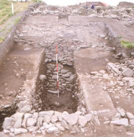
In addition to this, for safety reasons the eastern part of the north section was excavated back to the 1975 truncation by the airport road. The section created by the 1975 road construction was also uncovered, cleaned and examined in detail. This enabled the examination of the complete mound sequence, which provided evidence for pre-broch activity and the construction of the broch tower.
Publication: Dockrill, S.J., Bond, J.M. & Turner, V.E. (eds.) 2002. Old Scatness Broch and Jarlshof Environs Project: Field Project 2001, Interim Report No. 7 (Data Structure Report). Bradford Archaeological Sciences Research 11. Bradford: Department of Archaeological Sciences/Shetland Amenity Trust.
2002
The excavation focused on the southern circuit of the broch tower, the eastern part of the 1975 section as well as the continued excavation of the middle Iron Age structures and post-medieval elements in the zone between the north section (west of the broch) and the 1975 section. An area outside of the ditched enclosure was investigated by the Shetland Amenity Trust in advance of further of building associated with the presentation of the archaeology.
Publication: Dockrill, S.J., Bond, J.M. & Turner, V.E. (eds.) 2003. Old Scatness Broch and Jarlshof Environs Project: Field Project 2002, Interim Report No. 8 (Data Structure Report). Bradford Archaeological Sciences Research 12. Bradford: Department of Archaeological Sciences/Shetland Amenity Trust.
2003
The 2003 field season focused on the excavation of the western part of the 1975 road section, the continued excavation of the broch tower including the excavation of the broch doorway, and the continued excavation of the middle Iron Age structures to the west of the broch and the later Iron Age structure to the east of the broch tower.
Publication: Dockrill, S.J., Bond, J.M. Nicholson, R.A. & Turner, V.E. (eds.) 2004. Old Scatness Broch and Jarlshof Environs Project: Field Project 2003, Interim Report No. 9 (Data Structure Report). Bradford Archaeological Sciences Research 13. Bradford: Department of Archaeological Sciences/Shetland Amenity Trust.
Sponsors: B.P. Exploration Operating Company, E.C. Special Transitional Programme, Historic Scotland, Scottish Natural Heritage, Shetland Amenity Trust, Shetland Enterprise Company, Shetland Islands Council Charitable Trust, University of Bradford.
Phase four
Excavation within Phase Four of the project concentrated on the areas required in preparation for the consolidation of the structures.
2004
The excavations in 2004 concentrated on the early first millennium AD building to the east of the broch. This building was infilled by ash rich midden in the fourth century AD.
A medial wall bisects the large oval structure and work concentrated on identifying the initial sequence of midden infilling and late floor surfaces either side of this dividing wall. These deposits were found to be rich in animal bone (including articulated elements) and artefacts including fragments of imported glass, copper alloy and iron objects.
Publication: Dockrill, S.J., Bond, J.M. & Turner, V.E. (eds.) 2005. Old Scatness Broch and Jarlshof Environs Project: Field Project 2004, Interim Report No. 10 (Data Structure Report). Bradford Archaeological Sciences Research 15. Bradford: Department of Archaeological Sciences/Shetland Amenity Trust.
2005
Work in 2005 continued to define the late usage of the early first millennium AD building to the east of the broch. The midden infill and floor surfaces to the south of the medial wall proved to be rich in copper alloy artefacts and animal bone. Fragments of imported glass, including a bracelet fragment were also recovered from these deposits.
A small extension to the south of the main excavation area was opened up enabling the corridor to the wheelhouse (south of the broch) to be investigated. The structure within which a smaller wheelhouse sits was investigated in order to further understand this structure without removing the wheelhouse.
Publication: Dockrill, S.J., Bond, J.M. & Turner, V.E. (eds.) 2006. Old Scatness Broch and Jarlshof Environs Project: Field Project 2005, Interim Report No. 11 (Data Structure Report). Bradford Archaeological Sciences Research 16. Bradford: Department of Archaeological Sciences/Shetland Amenity Trust.
2006
The large roundhouse was excavated to its primary floor surface in readiness for consolidation of the structure. Due to the sectioning of the structure by the 1975 road cut, pre-structural deposits and the structure's relationship to the broch could also be investigated. The area to the north west of the broch was extended and the first deposits encountered related to the croft house excavated in 2003. This structure and its associated post-medieval deposits sealed a Pictish multi-cellular complex.
Publication: Dockrill, S.J., Bond, J.M. & Turner, V.E. (eds.) forthcoming. Old Scatness Broch and Jarlshof Environs Project: Field Project 2006, Interim Report No. 12 (Data Structure Report). Bradford Archaeological Sciences Research 17. Bradford: Department of Archaeological Sciences/Shetland Amenity Trust.
Sponsors: BP Exploration Operating Company, European Union (European Agricultural Guidance and Guarantee Fund), Historic Scotland, Scottish Natural heritage, Shetland Amenity Trust, Shetland Enterprise Company, Shetland Islands Council, University of Bradford, Heritage Lottery Fund, Shetland Islands Council Development Trust.